小学校の頃からお墓にお参りに行って本堂でおみくじをひくのが毎週末の行事でしたけど、山に登ったのは覚えている限りでなぜか1度くらいしかありません。
A mountain in Mitaki, Souko-yama, is like 10 min. from my home.
Since I was an elementary school student while I was in Hiroshima, I've visited my uncle's grave with my grandparents and picked omikuji (a written fortune teller) was my weekend routine, but climbing a mountain is not a part of my memory for some reason. Maybe just once?
この看板も最近できたんでしょうね、初めて見ました…
This sign was not there back then...
This time I went there for a sake of rediscovering a charm of my neighborhood.

入口の階段を登るとすぐに…
A、Bコースの分かれ道が。
There is a stone which tells you course A or B.
まずはAコース(山頂まで1,900m)に進みます。
First, I took course A (about 1,900m to the top).
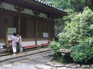
本堂前の手水舎(てみずや)。
Temizuya, where you wash your hands and mouth before going into Hondo, a main hall.

その左奥がAコース入口です。
A course is at the left behind of Temizuya.
少し進むと竹林が。
A beautiful trail continues.
分岐にはだいたい標識があるので迷いませんよ。
There are signs at where trails are split, so no worries to get lost.
分かります? この暑さ。陽が白いでしょう…
It was around 14:30.
ちょうどこのころ14:30ごろでした。
Are we there yet?
Yes! Nice view of the Seto Inland Sea.
じゃ、Bコース経由で下りましょう。
ok, let's go down with course B.
山頂から少し下ったところです。
This was taken from a bit lower than a top.
太田川が見えますね。
You can see Ota river, can't you?
そんなにかからなかったですね、山頂からは。
Going down didn't take long.
じゃ、逆で行ってみます? B→Aで:)(つづく)
Well, shall we do another one then?
Let's do course B and then A. To be continued...


